|
Services
We offer custom still-photo and video aerial photography services to
resorts, hotels, construction companies, Residential and Commercial Real
Estate firms, factories, pollution-control organisations, marine patrol
services, golf courses, government organisations, and more.
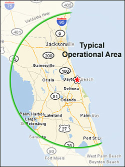
 From our base in
Daytona Beach, Florida, we are able to cover the entire
State of Florida, with most effective coverage of the area from Vero Beach
North to the Florida/Georgia border and across to the Florida West Coast. From our base in
Daytona Beach, Florida, we are able to cover the entire
State of Florida, with most effective coverage of the area from Vero Beach
North to the Florida/Georgia border and across to the Florida West Coast.
We have also conducted assignments across the country and
in other parts of the world, where we fly commercially to the distant
location and then hire an appropriate aircraft or helicopter to conduct the
assignment.
Equipment
We use fixed wing aircraft and helicopters, and even ground-based aerial
platforms such as balloons and radio-controlled helicopters, together with a
mix of digital and traditional-film photographic equipment, to capture just
the right detail and information for your requirements.
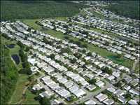
What can Aerial Photography do
for your company?
Aerial photography is an underutilized tool that can be
highly effective for the marketing, monitoring and measuring of private and
commercial property developments, roads, rivers, construction projects,
environmental areas, factories and similar facilities.
Remote construction sites can be
monitored on a weekly or monthly basis, with digital images being fed to the
Head Office the same day they are taken.
Aerial photos can be excellent
marketing & advertising tools for magazines, Annual Reports, posters,
instructional maps, promotional materials such as mousepads, deskpads, and
striking postcard marketing.
Viewing the world from the air allows one to observe
numerous factors that may not be apparent from the ground. These include -
- Allowing a single view of an entire property, thereby giving the viewer a
far better understanding of the layout of a property, it's boundaries, it's
relative position to various local developments, etc
- Determining the flood-plain of an area of land, ie. the ability of large
areas of land to withstand extended periods of rain
- Measuring the effectiveness of insecticides or herbicides on crop growth
or foreign plant control (including the use of infrared aerial photography)
- Locating pollution outflows into rivers and oceans
- Locating large foreign objects
- Viewing the performance of pollution control systems, both liquid and
gaseous
- Determining the effects of waves and currents on shorelines & breakwaters
- Conducting bird and other wildlife counts
 Aerial photography is also used
for - Aerial photography is also used
for -
- Perimeter security planning
-
Landscape planning
- Annual Report photographs
- Employee training tools, including fire and evacuation drills
- Traffic flow surveys
- Parking lot planning
- Movie location scouting
- And lots more!
Contact us for a quotation.
View our aerial photography
examples
|
Aerial
photo examples
AERIAL PHOTOGRAPHY
What's it worth?
Potentially,
Billion$
!
Sam Walton, founder of
WalMart stores, knew
something about the value of aerial surveys. And considering what he
accomplished in building the WalMart empire, one of his secrets is worth
noting.
Mr Walton knew exactly where he
wanted to build his stores - right in the middle of the growth-path of the
strongest residential development that was going on just outside a
town or city.
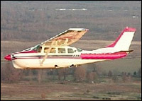
Older Cessna 210, similar
to
Sam Walton's first aircraft.
He needed a practical way to
accurately determine which direction a town or city was growing in. He could
have used statistical information from the local City Hall, but Sam Walton
had a quicker, more fool-proof tool to use.
He
simply took
his Cessna 210 aircraft with an assistant, flew around the prospective town
or city, taking careful note of all new housing developments and observing how
- and in which directions - the area was growing.
Once he knew the path of the growth, he took aerial photos of prospective
store locations, found out who the owners were, and went about buying
up just the property that he wanted, right in the location he had targeted.
If you look around you today,
you'll find that Sam Walton's aerial survey efforts, along with some sharp
business acumen, paid off. Most WalMart stores are placed just where Mr
Walton would have wanted them - right in the middle of the growth-path of a
town.
Now think how aerial
photography, or an aerial survey captured on video tape, could benefit your
business.
Contact us for a quotation.
View our aerial
photography examples
|